City Archives & Special Collections

From Common and Basin to Tulane and Loyola

circa 1946

From Common and Basin to Tulane and Loyola

130 Years of Change in our Neighborhood

In the last quarter of the 20th century, the Central Business District changed as radically as it did when it was developing during the 1820s and 1830s. Many of the old structures have been preserved and converted for new uses. Today this section of the city bustles with commercial, business, governmental, educational and recreational activities.

This was how the Greater New Orleans Community Data Center (now simply The Data Center) characterized the Central Business District at the beginning of this century. Since then, and especially after Hurricane Katrina and the flood that followed, residential uses have begun to make their presence known in the section. The CBD has not finished changing yet.

The Uptown/Lake corner of Tulane and Loyola Avenues has been home to the Main Library for fifty-six years. Before that, though, the NOPL site housed a bus station, a parking lot, a court house, a police station, a prison, a soda water factory, a granite and marble yard, a saloon, and a number of residences. The property has changed along with the rest of the CBD.

This exhibit looks in some detail at the Main Library’s site and its immediate neighbors — three locations that have also undergone considerable change over at least the last century. The first of these, the Eye, Ear, Nose and Throat Hospital, has already completed its latest change, leaving the neighborhood behind; the second, the Pythian Temple, is in the midst of renovation for a new use; and the third, Duncan Plaza, is facing an uncertain future after the post-Katrina flood changed it forever.

While the main focus of the exhibit is on these three places across Tulane Avenue, Loyola Avenue, and Gravier Street from the library building, it also takes a quick look at two other neighbors — South Rampart Street on its River side and Charity Hospital on the Lake side. Rampart has seen its share of change over the years, and there is probably much more to come. Charity, too, has a storied past and an all too uncertain future.

Brooke H. Duncan, manager of the City’s Real Estate Utility Department, apparently had this photograph of the proposed Civic Center area taken by the Abrams Aerial Survey Corp., ca. 1946. We know that Abrams did a survey of the entire metropolitan area in that year, at a cost of $34,734.86, but this does not appear to be a product of that project.

City Planning Commission, Subject Files, Folder 434.

The vicinity of Common and Basin (and beyond), ca. 1880. P. Casse’s Granite & Marble Works had just moved to Common Street in October 1879, but Roberts & Co., the soda water factory, the gas works, and Charity Hospital had all been in the neighborhood for years.

Robinson’s Atlas of the City of New Orleans, Louisiana, 1883, Plate 4.

The City was interested in the Common & Basin area for public purposes as early as 1888 when it began renting a building on Basin Street from John H. Wilberding for use by the First Recorders Court. In November 1891, ordinance #5785 (Council Series) authorized the purchase of seven lots in the square bounded by Tulane, Franklin, Basin, and Gravier Streets from five owners (including Wilberding) for a total of $68,500. By 1908 the Criminal Court House and Parish Prison built on those lots dominated the neighborhood. Interestingly, the Pythian Temple is shown across Basin Street even though it had not yet been built. A notation on the map indicates that the information about the building was taken from the plans.

Sanborn Map Company, Insurance Maps of New Orleans, Louisiana, 1908, Volume 3, Sheet 264.

The map above shows the locations described in the exhibit. Some are still standing, some have been renamed, and some no longer exist.

This exhibit is divided into six sections; use the buttons below to jump to any section. Once you finish a section you can choose scroll onto the next one, or return to the top of the page to navigate to a different section.

Charity Hospital

Charity Hospital started in the Vieux Carré during the eighteenth century, moved around for a while (including several years on Canal Street in a building that later became the State Capitol), and wound up on Common Street in 1832. It continued to care for the less fortunate citizens of New Orleans, including many recent immigrants, at that same location until the flood of 2005 shut everything down. We can’t begin to describe all of the many changes that affected Charity during its days in the neighborhood, so we’ll just present a few interesting visual examples.

Hover over an image below to learn more about it; click on the text to view an enlarged image.

Early (ca. 1870) stereographic photograph of Charity Hospital on Common Street.

John N. Teunisson’s view of Charity Hospital probably dates from about 1905 since the Delgado Memorial Building, erected in 1908, is not yet in place. Also, the shutters on the Tulane Avenue offices do not appear in later photographs.

Postcard view of Charity Hospital, probably an enhanced version of Teunisson’s photograph.

A good view of Charity Hospital’s main building, taken from the courtyard during the early years of the twentieth century.

Palm trees decorated Tulane Avenue in front of Charity Hospital during the 1920s.

Another Franck view of Charity Hospital from Tulane Avenue during the 1920s.

Franck also captured this scene of patients in the Charity Hospital entryway in 1935.

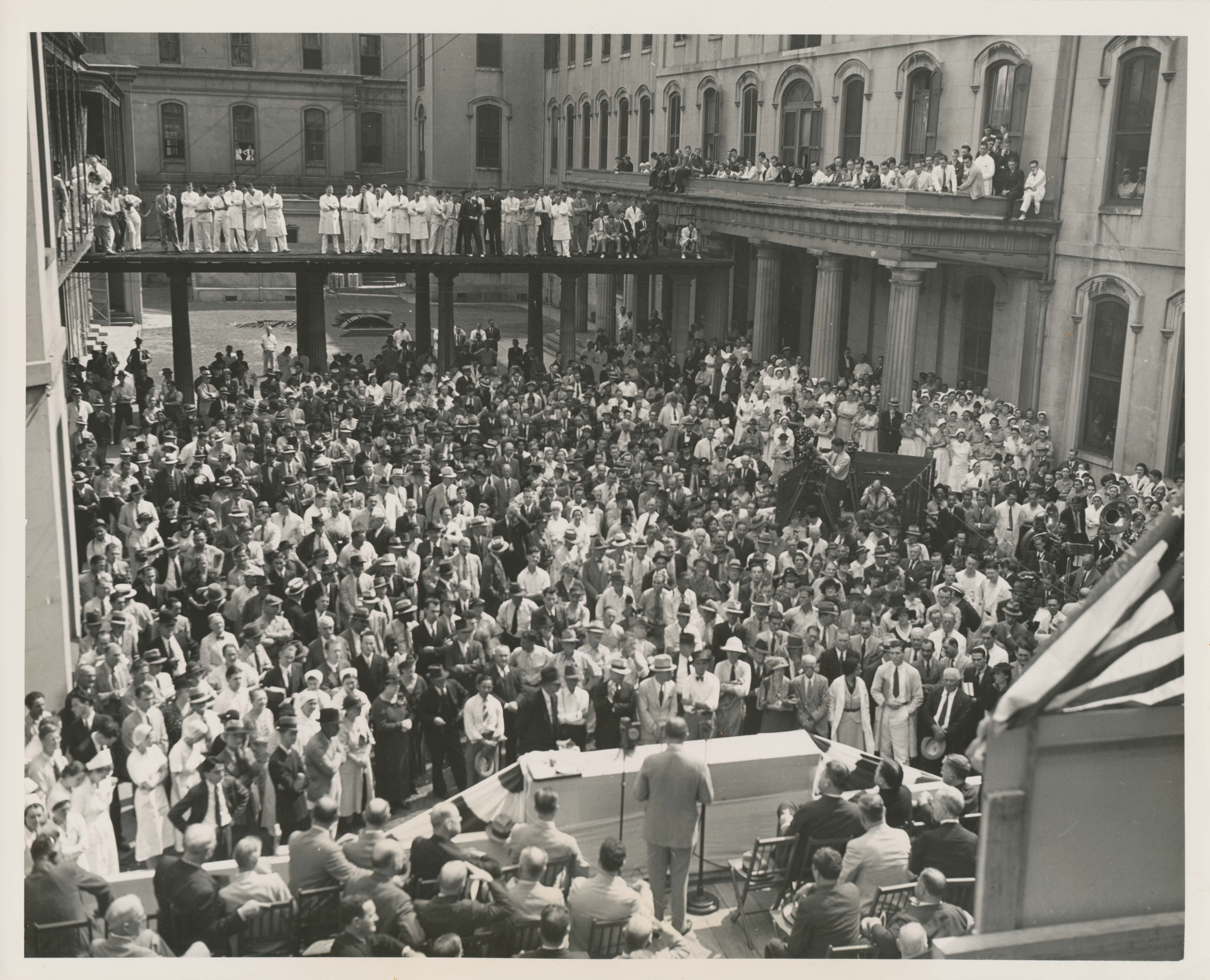
After 100 years on Tulane Avenue, Charity Hospital’s facilities were inadequate to meet the needs of a growing, modern city. Several new buildings were added to the overall hospital complex and, in 1936, a grant from the federal government made replacement of the main hospital possible. Demolition of “old Charity” began soon thereafter; this photograph shows the ceremonial beginning of that project in the hospital courtyard on September 17, 1936.

The demolition of “old Charity” in progress, November 4, 1936.

This April 15, 1938 photograph of Charity Hospital under construction was taken on the day after the topmost piece of steel was added to the building’s frame. It was taken from across Tulane Avenue, opposite the hospital. St. Katherine’s Church is visible in the foreground.

This postcard showing “Big Charity” was mailed in 1964.

A limited number of records from Charity Hospital are held at City Archives & Special Collections and are available to view on microfilm. Records date from 1818-1904 and are described here in greater detail.

Duncan Plaza

The Eye, Ear, Nose and Throat Hospital and the Pythian Temple were both half a century old when the Main Library opened for business in 1958. Our third featured neighbor, though, Duncan Plaza, is part of the same Civic Center development as the Library building. Designed as the open space element for the Civic Center, the Plaza has been the location for various ceremonial, musical, and other community events over the years. The post-Katrina flood, though, severely damaged the buildings immediately adjacent to the Plaza (the Louisiana State Office Building and the Louisiana Supreme Court), and they have since been demolished. Duncan Plaza remains as open space, but its future — along with that of the newly-created open space that adjoins it — is uncertain.

Square 304, bounded by Basin, Franklin, Perdido, and Gravier, included a mix of business and residential uses in 1880, as evidenced by this page from the tax assessment records. We also know, from the 1880 census, that Bernard and Mary Strauss, both natives of France, lived at 262 Gravier with a boarder and a servant. The census also tells us that Henry Turner, a native of Prussia, was at 99 Franklin with his wife, three sons, two daughters, a boarder, and a servant.

Orleans Parish Board of Assessors, Tax Assessment Rolls, 1880, First Municipal District, Fourth Assessment District.

Gravier St. Upper Side Street Rate Slips. 1897
Perdido St. Lower Side Street Rate Slips. 1897

The Underwriters Inspection Bureau’s street rate slips for Gravier and Perdido Streets show how the properties that would become Duncan Plaza were being used in 1897. The 1200 and 1300 blocks included a mix of residential, commercial, and industrial uses. Though the rate slips show only property owners, we know from the 1910 census that Louis Armstrong lived at 1303 Perdido with his mother and her companion. That corner, along with all of the area bounded by Perdido, Franklin, Gravier, and Locust Streets, lay within the Uptown counterpart to the better known Storyville district where prostitution was confined and tolerated from 1897-1917.

Underwriters Inspection Bureau of New Orleans, Street Rate Slips, 1897.

This early view of what was to become the Civic Center shows the old building stock still intact. In the center foreground is Union Sons Relief Association Hall, better known as “Funky Butt Hall,” an early venue for the music that became jazz (the one-story building on the corner to the right of the Hall is the house where Louis Armstrong lived; the large structure across from it is Fisk School where he was a student). Over to the left, of course, is the Pythian Temple and, across the street, a corner of the old Parish Prison.

New Orleans, La. Office of the Mayor, Annual Report, 1938.

An aerial view of the Civic Center area, this one from the middle of the CBD looking towards the lake, ca. 1947-1949. Note the large black gas holders behind Charity Hospital. They were built in the 1830s when James H. Caldwell started the city’s first gas works, and were finally dismantled to make space for construction of the Veterans Administration Hospital.

Louisiana Photograph Collection, Oversized Photographs, #164.

Another view of the Civic Center site, ca. 1947-1949.

1949 Aerial Photographs #E2.

Another view of the site taken on March 30, 1950, this one from across Tulane Avenue, opposite the Civic Center area. The old criminal court building demolition had only recently been completed and the project to widen Saratoga Street from Tulane to Poydras had just gotten underway.

Municipal Government Photograph Collection, Department of Property Management, City Hall/Civic Center, #53.

This aerial view of the Civic Center site, taken on March 30, 1950, shows most, but not all, of the old structures cleared away. Notable among those still standing, at the lower left, is St. Matthew’s Chapel Baptist Church (earlier the hall of Union Sons Relief Association, aka ”Funky Butt Hall”) at 1319 Perdido Street. Note also that the City was able to make a few extra dollars leasing the vacant land on the site for use as parking lots during the time before actual construction started on the project.

Municipal Government Photograph Collection, Department of Property Management, City Hall/Civic Center, #82.

A view of some of the buildings awaiting demolition on the future site of the Civic Center, probably on Franklin Street, ca. 1950. Note the Pythian Temple/Industries Building in the background on the left.

Municipal Government Photograph Collection, Department of Property Management, City Hall/Civic Center, #b (Photograph by Jerry Bray).

This reproduction of a plan from the City Planning & Zoning Commission shows the changes to the street system necessitated by the development of the Civic Center. Note that it shows Loyola (subsequently changed to Saratoga) remaining in use between Gravier Street and Tulane Avenue; that was before the decision was made to place the Library at its present location.

New Orleans, La., City Planning and Zoning Commission, Subject Files, 1927-1985, Folder #412.

Mayor deLesseps S. Morrison appointed Brooke H. Duncan as Director of the City Planning and Zoning Commission in 1947. Duncan, a long-time real estate professional, had been working on a plan for a new city government center since the 1930s. He died suddenly in 1950 as the Civic Center was just beginning to take shape. In recognition of his contribution to the project, the Center’s open space was named Duncan Plaza. In this letter from January 17, 1955, his son, Brooke Helm Duncan II, thanks the Commission for the honor.

New Orleans, La. City Planning Commission, Subject Files, 1927-1985, Folder 456.

The City made a few extra dollars leasing the vacant land on the Civic Center site for use as parking lots during the time before actual construction started on the project.

Municipal Government Photograph Collection. Department of Property Management, City Hall/Civic Center, #59.

This view of the Civic Center site on March 25, 1956 shows the old court house location completely cleared and the excavation for the Supreme Court building under way. Some parking remains on what was to become Duncan Plaza, but most of that space appears to be in use for construction staging.

Department of Property Management, City Hall/Civic Center, #115.

Commissioners Walter Duffourc, Victor Schiro, James E. Fitzmorris and Mayor Morrison welcome Angela Gregory’s bust of John McDonogh to Duncan Plaza, April 1957. The City had the statue moved from McDonogh Place (St. Charles Avenue at Toledano Street) so that the annual McDonogh Day ceremony could move from Lafayette Square and the old City Hall (Gallier Hall) to the new Civic Center.

General Interest Collection — New Orleans City Government, #177 (Photograph by Leon Trice Photography).

Carnival came to Duncan Plaza in 1959, as the downtown parade route was shifted to pass in front of the new City Hall instead of the newly-renamed Gallier Hall on St. Charles Avenue. The rerouting lasted only four years, though, as the parades returned to the old city hall in 1963. Here the Boeuf Gras float in the 1959 Rex procession makes its way along Perdido Street.

General Interest Collection — Mardi Gras, #22.

After Mayor Morrison died in a plane crash in Mexico in 1964, a corner of Duncan Plaza was turned into a monument to his life and career. This view shows the 38 foot tall column, incorporating a nine-foot tall statue of Morrison, overlooking a 40 x 100 foot pool/fountain. The latter element was filled in during the mid-1980s and, in 2002, a statue of civil rights leader Reverend Avery Alexander was added, facing the Morrison memorial. The Alexander statue was taken down in connection with the post-Katrina demolition of the adjacent State Office Building and has not yet returned to the Plaza.

Municipal Government Photograph Collection, Department of Property Management, City Hall/Civic Center, #c (Photo by Joseph C. Davi).

In 1976, the City dedicated a marble marker in Duncan Plaza in memory of Mr. Duncan. Brooke H. Duncan II (right) was joined by Planning Commission Executive Director Harold Katner, Mayor Moon Landrieu, and an unidentified woman (perhaps his sister, Catherine Duncan Banbury).

Municipal Government Photograph Collection, Department of Property Management, City Hall/Civic Center, #a.

In 1980, the City held a competition to select a design team to redevelop Duncan Plaza as a sculpture garden. Mayor Ernest N. Morial’s letter of April 15, 1981 conveyed the good news to landscape architect L. A. Torre that he and sculptor Robert Irwin had won the contest.

Office of the Mayor, Duncan Plaza Project Files, 1979-1981.

The Torre/Irwin team’s winning design called for an aviary—basically a giant birdcage—to be constructed over most of the Plaza, as depicted in the model shown here.

Office of the Mayor, Duncan Plaza Project Files, 1979-1981.

The Torre/Irwin plan for Duncan Plaza proved to be controversial, and the aviary was never really seriously considered. Several years later, Arthur Q. Davis developed a plan that kept the hills or berms envisioned in the earlier plan and also added a small performance pavilion based on the design of the African Hut at Melrose Plantation. The Davis plan, part of which is reproduced here, was built in the mid-1980s.

Building Plans in the City Archives, Renovation of Duncan Plaza,
Arthur Q. Davis and Partners, 1986, #R1579, Sheet L-1.

Eye, Ear, Nose & Throat Hospital

The Downtown/Lake corner was home to the Eye, Ear, Nose and Throat Hospital from 1907 until its demolition in 1996. Founded in 1889 to provide health care to lower-income residents of New Orleans, the Senses Hospital (as it was sometimes called) originally operated out of rented space on North Rampart Street. During 1903 and 1904, the institution’s Board of Trustees acquired most of the real estate in the square bounded by Tulane, Franklin, Cleveland, and Elk Place. Phase I of hospital construction resulted in a two-story clinic building along Tulane Avenue, while the hospital proper operated in the existing structures on Elk Place, including the corner with Tulane, until a new five-story addition went up in 1922. A third major building went up around the year 1950.


The Eye, Ear, Nose and Throat Hospital continued to operate on Tulane and Elk Place until 1988, when it moved into a new facility on Napoleon Avenue across from Southern Baptist Hospital. In the following year, an investor purchased the vacant downtown property at public auction. The old hospital sat empty until 1996 when it was demolished to make way for the Deming Pavilion, a residence for medical students at the adjacent Tulane Medical Center. That structure, with a Walgreen’s on the ground floor, continues in use today.

This page from the tax assessment record book for 1880 shows the owners of property and businesses in the square bounded by Basin, Franklin, Gasquet, and Common Streets. Two well-known madams, Kate Townsend and Fanny Hinckley (aka Fanny Sweet), owned lots on Basin Street and operated “furnished rooms,” as bordellos were often referred to. Miss C. Wallace also kept furnished rooms at the corner of Basin and Common — a property owned by J. L. Tissot, one of the judges of Civil District Court in New Orleans.

Orleans Parish Board of Assessors, Tax Assessment Rolls, 1880, First Municipal District, Fifth Assessment District.

The cover of the Eye, Ear, Nose, and Throat Hospital’s 1907 Annual Report shows the new clinic building facing Tulane Avenue with the old nineteenth century structures still standing next door.

Eye, Ear, Nose and Throat Hospital, Annual Report, 1907.

The 1924 Eye, Ear, Nose and Throat Hospital Annual Report featured the new hospital building on its cover.

Eye, Ear, Nose and Throat Hospital, Annual Report, 1924.

Reproduction of the elevation plan for the 1922 addition to the Eye, Ear, Nose and Throat Hospital.

Building Plans in the City Archives, Eye, Ear, Nose and Throat Hospital, Favrot and Livaudais, 1921, Sheet 5, #II-26.

The third major addition to the Eye, Ear, Nose and Throat Hospital was the Isaac H. Stauffer Memorial which was completed in 1950. This four-story, $700,000 structure allowed the institution to add more beds as well as to improve its research facilities.

General Interest Collection — Hospitals

View of the Eye, Ear, Nose and Throat Hospital from the California Building across the street, ca. 1952.

Municipal Government Photograph Collection, Photographs Arranged by Street Names — Elk Place, #2.

The Eye, Ear, Nose and Throat Hospital as seen from the Pythian Temple/Industries Building, ca. 1955.

Municipal Government Photograph Collection, Photographs Arranged by Street Names — Tulane Avenue, #12.

The Eye, Ear, Nose and Throat Hospital moved into new quarters on Napoleon Avenue in 1988 and the old facility was sold in the following year for $300,000. The buildings at Tulane and Elk Place sat vacant for eight years until their demolition in 1996. Though preservationists such as Diane Manget Gill feared that the vacant land would mar the CBD landscape for years, the Deming Pavilion was actually in the works before the end of the year. (Diane Manget Gill to Mayor Marc H. Morial, July 28, 1995).

Office of the Mayor. Records of the Executive Assistant for Intergovernmental Relations, 1994-1996, Box 4, Folder “Eye, Ear, Nose and Throat Hospital.”

Main Library Site

The Criminal Court Building was the most significant of the several structures that occupied the present-day site of the New Orleans Public Library’s Main Library. Built between 1892-1894, the Courthouse was described by the Times-Picayune as having “an imposing and handsome appearance. It is faced with pressed brick and trimmed with stone and terra cotta molded into such form and style as to entirely avoid monotony. It is, in fact, the only modern public building which New Orleans possesses.” But the construction project was plagued by corruption and questionable building practices, to the extent that the New Orleans Item later stated, “’Bribery Hall’ is a large red building, occupying the entire square bounded by Tulane avenue, Basin, Gravier, and Franklin streets.” Although the building dominated the neighborhood, it does not appear to have ever been popular with the citizens of New Orleans.

The Criminal District Court moved into a new building at the corner of Tulane and Broad in 1931, but the old structure remained standing for another eighteen years. Its eventual demolition paved the way for construction of the new Main Library as one piece of the city’s new Civic Center development. Interestingly, this was not the first time that Criminal District Court’s relocation affected the Library. When the Court moved into the building at Saratoga and Tulane in 1894, it left its old quarters, St. Patrick’s Hall, vacant. Mayor John Fitzpatrick shortly thereafter proposed, and the City Council subsequently approved, a plan to convert the building into the first home of the newly established New Orleans Public Library!

Most of the Basin Street frontage of square 303 (bounded by Basin, Gravier, Franklin, and Common) was taken up by the T. S. Waterman Soda Water Manufactory. Benedict Simon’s 1871 lithograph gives us a street view of the establishment.

Rare Vertical File — Views, Buildings, #3.

Ordinance #6050 (Council Series), passed on February 12, 1892, authorized the Comptroller to advertise for bids for the design of city buildings in square 303 to house the Criminal Court, the Parish Prison (with 350 cells), Police Headquarters, the First Precinct Police Station, and the Recorder’s Court. A contract for the design and construction of the project was soon awarded to M. A. Orlopp, Jr. There was a good deal of governmental corruption involved in the subsequent building of the structure, which itself proved to be poorly built and deficient in numerous ways. Little wonder that the new court house and jail were replaced within forty years of their completion. Here is the Criminal Court Building when it was almost brand new.

Art Work of New Orleans. (Chicago: W.H. Parish Publishing Co.), 1895.

This odd letterhead was in use just a few years after the Criminal Court Building opened. The drawing of the building looks similar to the actual structure but obviously isn’t quite right! And, of course, it was across Tulane Avenue from Elk Place.

Rare Vertical File — Letterheads — Organizations, #45.

This ca. 1908 postcard shows Elk Place looking towards the Criminal Court Building. It also shows some of the buildings that were on the future site of the Eye, Ear, Nose and Throat Hospital.

Postcard Collection — N. O. Streets, #43.

A “close-up” postcard view of the Criminal Court Building, with a bare glimpse of the corner of Tulane and Elk Place included. The City had been interested in the Common and Basin area for public purposes as early as 1888 when it began renting a building on Basin Street from John H. Wilberding for use by the First Recorder’s Court. In November 1891, ordinance #5785 (Council Series) authorized the purchase of seven lots in the square bounded by Tulane, Franklin, Basin, and Gravier Streets from five owners (including Wilberding) for a total of $68,500.

Postcard Collection — New Orleans Municipal Government, #I-31.

This 1948 view up Elk Place from Canal Street shows the Pythian Temple/Industries Building, Criminal Court Building, and the Eye, Ear, Nose and Throat Hospital all together at a time just before major change came to the scene. Note that foundation work appears to be underway for a new addition to the Eye, Ear, Nose and Throat Hospital.

Charles Franck Collection — Streets

The Criminal District Court, Parish Prison, and other government agencies moved from the corner of Tulane and Saratoga to the new Criminal Court Building at Tulane and Broad in 1931. The old building, however, continued in use for another eighteen years. The sign visible in this late 1940s photograph shows that the City’s Municipal Courts occupied the building, but it also housed such varied entities as a New Orleans Police Department substation and the Louisiana Sunshine Club.

Louisiana Photograph Collection, General Interest Collection — Buildings, Government, #175.

Demolition of the old criminal courts building was underway in the latter part of 1949.

Municipal Government Photograph Collection,
Department of Property Management, City Hall/Civic Center, #1.

Pythian Temple

The Eighth Wonder of the world is not located in the Orient, in the Occident, nor at the North Pole, but right in the city of New Orleans, in the prosperous State of Louisiana. It is not a temple that is dedicated to the gods, but it is a mammoth, modern, up-to-date building, dedicated to the living and built by Negro brains and Negro capital. The name of this pretentious and magnificent structure is the Pythian Temple of New Orleans, La.
Green P. Hamilton, Beacon Lights of the Race (Memphis, F.H. Clarke & Brother), 1911, p. 537.

In 1907, the Grand Lodge of the Knights of Pythias of Louisiana announced their plans to build a seven-story office building at the corner of Saratoga (now Loyola) and Gravier Streets. This was an ambitious goal for an African American organization at the height of the Jim Crow era, but it was realized in 1909 with the opening of the Pythian Temple. The attractive structure housed offices for local Black businesses, along with meeting space for the Grand Lodge, a theater, and a roof garden where a number of early jazz greats performed. The Pythians ran into hard times during the early 1930s, though, and lost the building in 1943. After decades of use as an office building, it is now undergoing a major renovation into a mixed use commercial/office/residential development by Green Coast Enterprises.

1897
Before the Structure

A. C. Becker operated the saloon on the corner of Gravier and Basin (1127-1133 Gravier) in 1897, ten years before the Knights of Pythias purchased the property for their proposed temple building. 

Underwriters Inspection Bureau of New Orleans, Street Rate Slips, 1897.

1903
Murder of Becker

In 1903, the Daily States described the site as a “ramshackle shack” in which Antonio Luciano and his wife lived and operated a modest fruit stand. Luciano, who had had previous bloody encounters with the Mafia, was murdered on Canal Street later that year.

New Orleans Police Department, Homicide Reports, 1903.

1908
Planning the Structure

The Diboll, Owen, and Goldstein plans for the Pythian Temple were published in the March 1908 issue of Architectural Art and Its Allies.

1910
Structure in 1910

The Pythian Temple, as depicted on its letterhead.

Rare Vertical File—Letterheads—Organizations, #30.

1913
Structure in 1913

This description of the Pythian Temple appeared in the December 30, 1913 edition of the Times-Picayune.

1922-1923
Structure in 1922-1923

This advertisement for the Pythian Temple in Colored New Orleans, 1922 & 1923, suggests the significance of the building for the African American community in the Crescent City and beyond. The publication also carried cards for several of the Temple’s tenants: Liberty Industrial Life Insurance Co., Inc., the New Orleans Bureau of Investigation, Guillaume College, and a dentist (Dr. Gomez, whose ad appears on the opposite page).

Colored New Orleans: High Points of Negro Edeavor, New Orleans, La : Colored Civic League of New Orleans, 1922-23.

1935
Structure in 1935

The city decided early in 1932 to demolish the old Parish Prison on Gravier Street behind the Criminal Court Building. This photograph, taken on August 20, 1935, shows that demolition project in progress. It also provides us with a good view of the Pythian Temple across Saratoga Street from the prison property. Note than an eighth floor had been added to the Temple building by this time.

General Interest Photograph Collection —Buildings, Government, #181.

1944
Structure in 1944

The Knights of Pythias ran into financial trouble when Octavia and Albertine Peterson sued them for a debt of $570 in 1933, and the Temple building was placed in receivership pending sale. In 1936, while the new Charity Hospital was under construction, the State leased the Pythian Temple as a temporary facility for Charity’s African American patients. After a number of legal delays, the building finally was sold, for $80,000, to the newly-formed Industries Realty, Inc., with R. E. E. deMontluzin as its president. Later in the year, Higgins, Inc. leased the building to house its employment offices and other uses.

1955
Structure in 1955

Early in 1955, as the Civic Center complex was beginning to take shape across the street, R. E. E. deMontluzin, owner of the Pythian Temple/Industries Building, renamed the structure as the Civic Center Building. A couple of years later, he added two floors and had the building renovated and modernized, with a new façade similar in style to the new City Hall. Here is a reproduction of the elevation for the Loyola Avenue façade, calling for “removal of terra cotta ornamentation” and the addition of porcelain panels and aluminum projected windows with fixed glass. The Pythian Temple thus went undercover.

Building Plans in the City Archives, Alterations and Additions to Building,
238 Loyola, 1957, Benson & Riehl, Plan # R0117, Sheet 6.

1960
Structure in 1960

This postcard, ca. 1960, shows the Pythian Temple/Civic Center Building, with its new façade, across a corner of Duncan Plaza.

Postcard Collection -- Central Business District, #13.

1962
Structure in 1962

1962, R. E. E. deMontluzin built a ten-story addition behind the Pythian Temple/Industries Building on Gravier Street. At the same time, he announced that the structure would be renamed the deMontluzin Building.

General Interest Photograph Collection—Office Buildings.

Rampart Street

“South Rampart Street is the Harlem of New Orleans. For a distance of several blocks it teems with a great variety of shops catering largely to the Negro population. Countless cafes and refreshment stands are in evidence, and music-store phonographs supply the visitor with an introduction to local Negro melody. The street, which is seen to its best advantage on Saturday evenings, when it is crowded with shoppers and pleasure-seekers has afforded material for numerous literary works. . . . “

Federal Writer’s Project (New Orleans, La.) New Orleans City Guide (Boston: Houghton Mifflin, 1938), p. 331.

Circus Street Infirmary

One of the city’s early hospitals was the Circus Street Infirmary located on South Rampart (the street’s name was changed in 1852) between Poydras and Perdido Streets. Started in 1841 by Drs. Campbell and Mackie, it remained in operation at least until 1878. The Infirmary building is no longer standing, but several landmarks in the history of jazz do remain in the 400 block—the Iroquois Theater, the Karnofsky tailor shop, the Eagle Saloon, and the recently renovated and reopened Little Gem Saloon.

Circus Street Infirmary Account Book, 1841-1842. SC-171-MS.

100 Block of South Rampart Street

The 100 block, at least, of South Rampart Street appears to have been quite fashionable during the nineteenth century. The F. Cazelles store at 153 S. Rampart had been described in a 1902 auction advertisement as “a magnificent mansion…leased as a fashionable apartment house until September 30, 1902, at the rate of $2,400 per annum.” The Cazelles, who had moved back to Paris, finally sold the mansion, along with the adjacent buildings that comprised part of New Orleans Chinatown, for $61,500 in 1907. It was demolished at the same time as Chinatown, in October 1937. Just a few doors down from the Cazelles mansion stood the former home of Mrs. Thomas J. Semmes, described by the Daily Picayune in 1898 as “the center of a most cultured and refined circle, and all that is best in the world of letters and art. . . .”

New Orleans, Louisiana, the Crescent City: the book of the Picayune also of the public bodies and business interests of the place (New Orleans: Geo. W. Engelhardt, 1903-1904), p. 169.


The status of the 100 block of South Rampart is confirmed by the 1899 edition of Soards’ Elite Book of New Orleans. Subtitled A Directory of Selected Names of Those Whose Patronage Would Be Desirable, the volume lists Mr. & Mrs. Semmes and also the prominent physician Stanford Chaille as residents of the block.

Soards’ Elite Book of New Orleans (New Orleans: L. Soards, 1899), p. 117.

The Chicago Hotel

Alfred O. Smith operated the Chicago Hotel at 204-206 South Rampart Street “for the highest class colored people” from 1907 until 1914 or 1915. This page from the hotel’s guest register during April 1910 shows that the Williams and Stevens Stock Company stayed there while performing at the Temple Theater (in the Pythian Temple). They had previously appeared at the Theater’s formal opening on September 26, 1909.

Chicago Hotel Guest Register, 1907-1912. SC-318-MS.

Advertisement for the Chicago Hotel and Restaurant, 1914.
Business card for the Chicago Hotel.

Chinatown

Some of the licensed Chinese businesses operating in the Chinatown section.

New Orleans Police Department, Report of Police Officers on Licenses Paid and Unpaid, 1922, First Precinct — Rampart to Broad/Canal to Julia.

“ONE SHOT DEAD AS TONG WAR INVADES NEW ORLEANS” was the headline in the Times-Picayune on the day following the murder of Chin Soo just a few steps off South Rampart Street in Chinatown. Here is the New Orleans Police Department report on the crime.

New Orleans Police Department, Homicide Reports, 1925.

South Rampart Street Parade came out of New York City rather than New Orleans, but co-composer Ray Bauduc was a native of the Crescent City. The song captures the spirit of a local street parade and it quickly became a hit after its release in 1938.

Early Recording Collection. 30A. This collection is not currently available to view.

Two images from South Rampart Street that perhaps suggest a less enthusiastic view of the area than that presented by the 1938 City Guide, at least on the part of educator and sports journalist Champ Clark. What he characterized in 1942 as “New Orleans Beale Street” has more recently been summed up with these words from John Hasse, Curator of American Music at the Smithsonian Institution: “There is probably no other block in America with buildings bearing so much significance to the history of our country’s great art form, jazz.”

Peter Wellington Clark, Delta Shadows: a Pageant of Negro Progress in Orleans (New Orleans: Graphic Arts Studios, 1942), p. 144.

The 200 and 300 blocks of South Rampart Street were mostly still intact when this photograph was taken in 1960, including the former Chicago Hotel on the corner across from the Oil and Gas Building. Some of the old buildings remain in place even today, but there are more high-rise buildings and parking lots than anything else. Off in the distance, though, on the far side of Poydras Street, the new South Market District is now being built. In the words of the project developers, it “combines stylish residences with exciting new retail, restaurants, and entertainment venues in the heart of Downtown New Orleans.” Yes — the CBD is still changing!

Municipal Government Photographs Collection. Photographs Arranged by Street Names — South Rampart Street, #2.

This exhibit was originally created in 2014  by Wayne Everard, Irene Wainwright, and Cheryl Picou. The title images were designed by NOPL Graphic Designer Catherine Burke. It was updated and revised by Amy DeNisco in 2024.

Exit mobile version